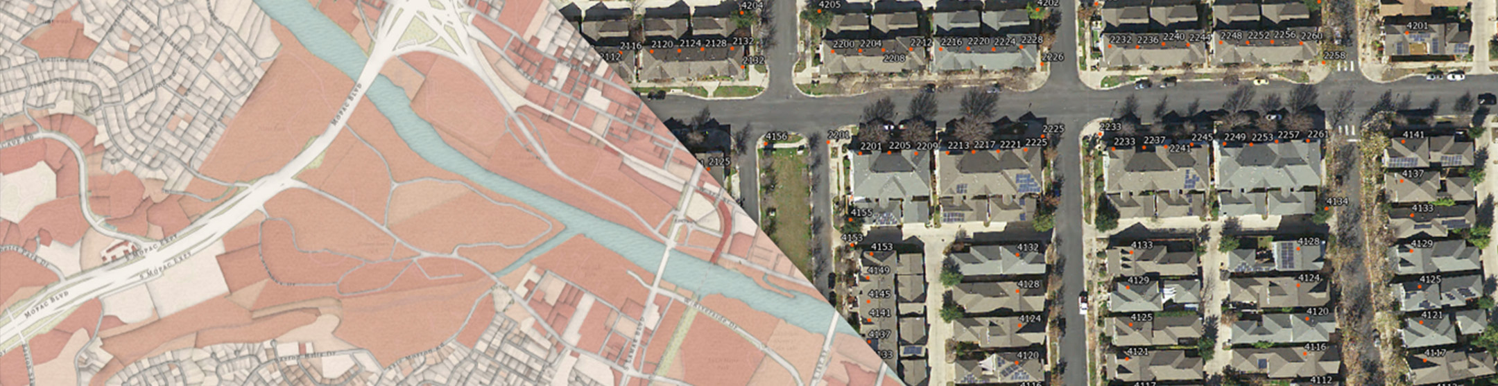
Address points
Address points are site or structure point data that have associated information such as house number, street name, postal community, and postal code. This information is recorded and maintained at the city and county level in Texas and aggregated to Regional Planning Commissions or Emergency Communications Districts. It is then used by public entities to make informed decisions on community planning, development, or emergency preparation and response.
In collaboration with stakeholders from across Texas, TxGIO created a statewide standardized GIS address point schema. This format of site/structure address point data consists of the most commonly utilized information as determined by the address point committee. The data contributed from 9-1-1 Service Entities were translated into this common schema and are now available on the TxGIO DataHub.
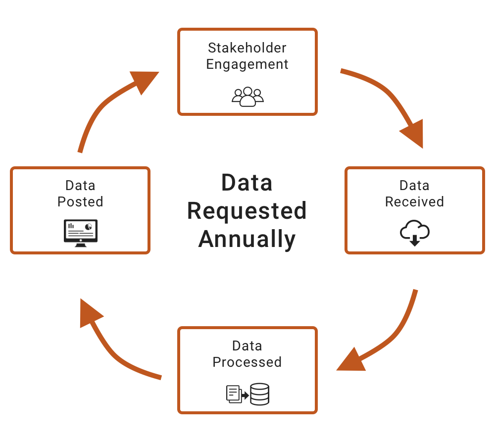
Program Flow
This iterative program flow will occur throughout the year. At no one time will there be a completed or final version of data as each data source has varying update schedules. Please check each county for the most recent version of data.
Agency Address Point Uses
Texas State Agencies make extensive use of Address Point data for all types of operations and applications.
General Land Office (GLO)
- Management of state lands and coastal land permitting
- Community development/revitalization
- Veteran’s benefits issue management
Texas Division of Emergency Management (TDEM)
- Mitigate emergency situations by accurately modeling and mapping areas to predict flooding along high-risk areas
- Planning and early evacuation procedure
Texas Department of Transportation (TXDOT)
- Right of Way management for private or state-owned lands
- Transportation planning
Health and Human Services Commission (HHSC)
- Determine structures in the path or vicinity of disease outbreak
- Analyze economic conditions for services
Texas Water Development Board (TWDB)
- Determine if structures will be affected by flood conditions for early evacuation
- Determine properties that will be affected with the build of a new dam.
Texas Animal Health Commission (TAHC)
- Locate farms, ranches, feedlots, etc in the event of animal disease outbreak
Texas Commission on Environmental Quality (TCEQ)
- Air permitting and air quality monitoring/analysis
- Determining water rights for landowners
- Water quality planning based on growth.
Texas Parks and Wildlife Department (TPWD)
- Land ownership notification
- Property transactions, planning, and management
- Emergency management and response.
Commission on State Emergency Communications (CSEC)
- Statewide emergency communications.
Department of Public Safety (DPS)
- Emergency management and response.
FAQ - Frequently Asked Questions
Who created these address points?
The authoritative data source for these address points are the 9-1-1 coordinators across Texas. This includes a combination of city, county, and regional sources that vary by community. TxGIO created partnerships with these entities and their authorized aggregators to compile and share this statewide address point dataset available to the public for FREE. Authorized aggregators include the Commission on State Emergency Communications and the Texas 9-1-1 Alliance or their respective third party vendors. TxGIO does not edit these data.
What is the purpose of these address points?
These address points were created for 9-1-1 call routing purposes; however, they are now available for public use. The Next Generation 9-1-1 (NG911) system will rely heavily on the accuracy of geospatial data, including address points. As a result, these data are continually scrubbed and analyzed for use within the NG911 system by the authoritative data sources and their vendors. Over time, these data may change based on GIS standards established by the National Emergency Number Association (NENA) or for other reasons. TxGIO does not edit these data.
Why is TxGIO compiling a statewide address point dataset?
The 2016 Geographic Information Office Report identified a need for statewide address points. These data are required for non-9-1-1 purposes to conduct state business including the following agencies: Texas Parks and Wildlife Department, Texas Animal Health Commission, Texas General Land Office, Texas Water Development Board, Texas Department of Public Safety, Texas Department of Aging and Disability Services, Texas Department of Insurance, and Texas Commission for Environmental Quality.
How frequently are these address points updated?
TxGIO will attempt an annual refresh from authoritative data sources or their authorized aggregator. The refresh rate will vary across the state. Some data may refresh multiple times within one year. The date of the address point dataset is included in the file name as YYYYMM.
Where are the points placed? Rooftop, parcel centroid, along street centerline?
Each authoritative data source has their own guideline and policy on the placement of the point data. TxGIO is not able to influence or edit the point placement or attributes. TxGIO does not edit these data.
What is the Commission on State Emergency Communications?
The Commission on State Emergency Communications (CSEC) is an agency of the State of Texas and the state’s authority on emergency communications. CSEC is charged with administering the State 9-1-1 Service Program and the Statewide Poison Control Program. The Commission consists of 12 members representing various public and private sector interests. Nine members are appointed by the Governor, Lieutenant Governor and the Speaker of the House of Representatives to represent cities, regional planning commissions, county government, emergency communications districts, and the general public. Three members are ex-officio, non-voting members named in statute.
What is the Texas 9-1-1 Alliance?
The Texas 9-1-1 Alliance is an interlocal cooperation entity composed of 27 Texas emergency communication districts with E9-1-1 service and related public safety responsibility for more than approximately 70% of the population of Texas. These emergency communication districts were created pursuant to Texas Health and Safety Code Chapter 772 and are defined under Texas Health and Safety Code Section 771.001(3)(B).
What is the National Emergency Number Association?
The National Emergency Number Association (NENA) serves the public safety community as the only professional organization solely focused on 9-1-1 policy, technology, operations, and education issues. With more than 13,000 members in 48 chapters across North America and around the globe, NENA promotes the implementation and awareness of 9-1-1 and international three-digit emergency communications systems. NENA works with public policy leaders; emergency services and telecommunications industry partners; like-minded public safety associations; and other stakeholder groups to develop and carry out critical programs and initiatives; to facilitate the creation of an IP-based Next Generation 9-1-1 system; and to establish industry leading standards, training, and certifications.
Contact Us
Contact TxGIO with any further questions regarding this program and someone from StratMap will get in touch with you.
Contact Us