Txgio
Texas GIS Forum Main Image


Day 1 - Monday, October 23

8:00 AM - 12:00 PM

Career Planning - GISP Certification

Brian King, Freese & Nichols

Location: J.J. Pickle Research Center


Overview:

The workshop will provide participants an overview of the history of the GISP certification, its current requirements, and a preview of the new exam. **Prerequisites:** Interest in learning about the GISP Professional Certification

Learning Objectives:

Are you interested in learning more about the GISP? Hear about it from a local GIS professional who has earned the GISP, among other certifications. Get your questions answered and get motivated to submit for this industry credential.

About the Speaker:

Brian King, Freese & Nichols

Brian King, GIS Mapping Specialist and Archeologist with Freese & Nichols’ (FNI) Austin, TX office. His responsiblities include drafting and design tasks in the areas of floodplain modeling and mapping, hydrology and hydraulics, Drone / UAS Mapping, water resources studies, ArcGIS web mapping, ArcGIS Data Collection apps, photogrammetry, remote sensing, and Lidar processing. With 19 years working in the engineering, environmental, and archeology fields, he has a passion for the industry, specifically geospatial solutions. He is an assistant instructor at the Pennsylvania State University John A. Dutton e-Education Institute, College of Earth and Mineral Sciences. Through his involvement with URISA Texas for many years, he has received recognition as a leader in the field of GIS and has served in numerous State and National elected and appointed positions.


8:00 AM - 12:00 PM

Insights For ArcGIS

Brig Bowles, ESRI; Zena Pelletier, ESRI

Location: J.J. Pickle Research Center


Overview:

Insights for ArcGIS is a new user experience for analysis available at ArcGIS 10.5 that focuses on simpler ways to work with your data to answer questions and share results including visualization first, drag and drop analytics and, on the fly filtering and aggregations. Insights for ArcGIS is designed to make interactive and exploratory analysis fast and intuitive so you can gain understanding from your data in a spatial context. Learn techniques in wrangling your data for analysis, best practices in working with Insights and its analysis capabilities and more.

Learning Objectives:

Insights for ArcGIS is a web-based, data analytics workbench where you can explore spatial and non-spatial data. Answer questions you didn't know to ask. And, quickly deliver powerful results. Use maps, charts, and tables to visualize and tell your story like never before. Advanced algorithmic spatial analysis is as simple as drag-and-drop.

About the Speaker:

Brig Bowles, ESRI

Joseph Brigham Bowles is a Solutions Engineer and works out of the Esri San Antonio office. He has been with Esri for twenty plus years focusing mainly on the technical side of the sales process. His experience is in helping companies and individuals get their data into a spatial format to better find answers to questions. His areas of expertise include web mapping, server based GIS, developer technologies, and making spatial technology available to everyone.

Zena Pelletier, ESRI

Zena Pelletier is a Solution Engineer on the State & Local Government team out of the San Antonio Regional Office. She has been with Esri 3 ½ years and she works with local governments in the region to make full use of Esri software and technology. She enjoys helping users deploy solutions to meet their business needs and objectives.


8:00 AM - 12:00 PM

Introduction to Spatial Statistics Using ArcGIS and R

Eric Pimpler, Geospatial Training Services

Location: TCEQ Computer Training Lab


Overview:

This hands-on session will introduce the student to the Spatial Statistics toolbox in ArcGIS and how to use the functionality provided by these tools. We'll discuss hot spot analysis, cluster and outlier analysis, and others. Prerequisite: Intermediate level ArcGIS knowledge.

Learning Objectives:

This hands-on session will introduce the student to the Spatial Statistics toolbox in ArcGIS and how to use the functionality provided by these tools.

About the Speaker:

Eric Pimpler, Geospatial Training Services

Eric is the founder and owner of GeoSpatial Training Services (geospatialtraining.com) and has over 25 years experience as an application developer, data scientist, and trainer using ArcGIS Desktop, ArcGIS Enterprise, ArcGIS Online, and ArcGIS Pro. Eric is currently focused on data science applications with Python, R, and GIS. Eric is the author of Data Visualization and Exploration with R, Programming ArcGIS with Python Cookbook, Building Web and Mobile ArcGIS Server Applications with JavaScript, Spatial Analytics with ArcGIS, ArcGIS Blueprints, and Programming ArcGIS Pro with Python. Eric has a Bachelor’s degree in Geography from Texas A&M University and a Master's of Applied Geography degree with a concentration in GIS from Texas State University.


1:00 PM - 5:00 PM

Building Beautiful Spatial Analysis with CARTO Builder

Jeff Ferzoco, CARTO

Location: J.J. Pickle Research Center


Overview:

This workshop will offer several exercises using CARTO Builder's analysis, SQL functions, and styling to increase understanding and data visualization. Topics covered: importing data, styling data by values, analysis, publishing, and sharing. Also, the discussion will venture into advanced SQL and data augmentation. The discussion will move from beginner to intermediate with a bit of advanced techniques and reserve tie for Q&A at the end. Bring your laptops!

Learning Objectives:

Want to learn about CARTO Builder's analysis and more? This workshop will cover a lot of information from beginner to intermediate with some advanced techniques, too.

About the Speaker:

Jeff Ferzoco, CARTO

Jeff Ferzoco is a designer and mapper working with CARTO on their public-sector team. His background is in information design/mapping, urban planning and data visualization – and where all of those blend together. Jeff has taught urban data and mapping at Pratt’s SAVI program and Columbia University/GSAPP. He loves coding, cartography and making things understandable and insightful – and teaching others to do it themselves.


1:00 PM - 5:00 PM

Census Data for GIS

Lacey Loftin, U.S. Census Bureau

Location: J.J. Pickle Research Center


Overview:

Have you ever struggled to integrate data from the Census Bureau's website into your GIS? This 3-hour session will cover everything you need to know. From understanding and selecting the proper census data, to formatting the data in ArcGIS. We'll cover the various types of Census geography, data sources and programs, data retrieval from American Factfinder, and data presentation in ArcGIS. Students: please bring your laptops to the session. Data will be pulled directly from the USGS website.

Learning Objectives:

This 3-hour session will cover everything you need to know. From understanding and selecting the proper census data, to formatting the data in ArcGIS.

About the Speaker:

Lacey Loftin, U.S. Census Bureau

Lacey Loftin is a statistician with the United States Census Bureau. In the 14 years that she has been with the agency, she has served as an Analyst for the Economic Census, supervised data collection operations, acted as a congressional liaison during the 2010 Census, and worked to create the Statistics in Schools program. Lacey's time is now focused on outreach to organizations and governments in Texas, sharing data, tools and useful applications.


1:00 PM - 5:00 PM

Esri Maps & Apps - Field, Office, Public & Developer

Michael Beavers, ESRI; Katherine Smyth, ESRI

Location: J.J. Pickle Research Center


Overview:

During this workshop, attendees will learn how to leverage their investment in the ArcGIS Platform through ArcGIS Online and via Portal for ArcGIS. Esri will cover the Web Map which is the fulcrum of Web GIS and how Web Maps feed a suite of focused, off-the-shelf Apps that can be used in the office and in the field.

Learning Objectives:

During this workshop, attendees will learn how to leverage their investment in the ArcGIS Platform through ArcGIS Online and via Portal for ArcGIS.

About the Speaker:

Michael Beavers, ESRI

Michael Beavers is a Solution Engineer with Esri where he focuses applying his product expertise to formulating web-based GIS solutions for customers in Local Government and the Aviation Industry. Mike has extensive experience in GIS management. He worked as a GIS Manager/Coordinator in the private sector and in local and regional governments. A military veteran, Captain Beavers was an Instructor Navigator in the Air Force. He flew as a commercial/airline pilot after his military service. Michael earned a B.S. from Texas State University, where he concentrated on cartography, photogrammetry, remote sensing and computer science. He earned a Master’s Degree in GIS from New Mexico State University.

Katherine Smyth, ESRI

Katherine Smyth is a Solution Engineer with Esri where she works with local governments to support their growth as GIS-powered organizations. Before Esri, Katherine used GIS to support private and public organizations specializing in archaeology, terrestrial planet exploration and natural resources. Katherine earned a BA in Anthropology from CU Boulder in 2007 and an MS in GIS from the University of Redlands in 2013.


Day 2 - Tuesday, October 24

8:00 AM - 12:00 PM

Everything You Want to Know About Open Source GIS But Were Afraid to Ask

Caitlin Schneider, AppGeo; Kate Hickey, AppGeo; Michael Terner, AppGeo; Ross Topol, AppGeo

Location: TCEQ Computer Training Lab


Overview:

If you’ve ever wondered about or experimented with Open Source technology for your GIS operation, this workshop is for you. In the age of data science, the Internet of Things (IoT), and cloud computing, GIS “software as usual” approaches are due for an upgrade, and lower cost choices are emerging. Whether you are looking for a GIS tune-up or an enterprise GIS overhaul, Open Source options are mature enough to be strongly considered. This workshop will explain and demonstrate Open Source potential from three key perspectives that can help you start, or continue, your adoption path: (1) the Open Source ecosystem - why it exists and how it operates to your benefit; (2) Open Source technologies - what’s out there, advantages and disadvantages, and how OS can enhance existing enterprise GIS; and (3) the Open Source adoption path - how to get started, how to build internal support and show results, and how OS can help drive organizational change. The workshop will include real world case studies that can be adapted to your situation. It will draw from the AppGeo team’s direct and substantial experience with a variety of Open Source geospatial IT technologies and platforms, and bring to Texas what we learn from organizing, co-chairing, and participating in the 2017 International Free and Open Source Software for Geospatial (FOSS4G) conference that is taking place in Boston this August.

Learning Objectives:

If you’ve ever wondered about or experimented with Open Source technology for your GIS operation, this workshop is for you.

About the Speaker:

Michael Terner, AppGeo

Michael Terner, is the Executive Vice President of AppGeo. His leadership at AppGeo began with co-founding of the company in 1991. During his more than 25 years at AppGeo, he has led initiatives to pioneer new approaches and to promote the use of emerging technologies. Through his project leadership, he has emphasized Open Source adoption. Michael has been at the forefront of telling AppGeo’s story of geospatial IT adoption and experimentation, and is a sought after speaker and facilitator. Currently, Michael is Chair of the Organizing Committee for the International FOSS4G (Free and Open Source Software for GIS) conference being held in Boston on August 14-18. FOSS4G is the largest global gathering focused on Open Source geospatial software.

Kate Hickey, AppGeo

Kate Hickey is a Vice President with AppGeo. She has been studying the business requirements of government, developing geospatial IT strategies, and planning GIS systems for federal, state, and local governments for over 15 years.

Caitlin Schneider, AppGeo

Caitlin Schneider is a GIS Analyst with AppGeo, in the Austin office. She has experience in detailed spatial data collection and processing methods, spatial and non-spatial data integration, quality control and data documentation.

Ross Topol, AppGeo

Ross Topol is a Full Stack Engineer with AppGeo, in the Austin office. He currently works on designing, building and maintaining custom web applications for a variety of AppGeo clients ranging from local municipalities to federal agencies. Ross is also an active member of the javascript community as a mentor to aspiring developers and as an advocate for open source technologies.


8:00 AM - 12:00 PM

Liberate Your Data with ArcGIS Online

Michael Beavers, ESRI; Katherine Smyth, ESRI

Location: J.J. Pickle Research Center


Overview:

Did you know that if you have an ArcGIS Online organizational account, you also have access to our free Open Data site? During this session we will cover the many ways to share your data with the public using ArcGIS Online and how to integrate maps and apps created with that data into an Open Data page that everyone can access.

Learning Objectives:

During this session we will cover the many ways to share your data with the public using ArcGIS Online and how to integrate maps and apps created with that data into an Open Data page that everyone can access. Please bring your own computer and some data that you would like to share with the public. Examples include a spreadsheet, shapefile or feature class - or something you've already shared to ArcGIS Online.

About the Speaker:

Michael Beavers, ESRI

Michael Beavers is a Solution Engineer with Esri where he focuses applying his product expertise to formulating web-based GIS solutions for customers in Local Government and the Aviation Industry. Mike has extensive experience in GIS management. He worked as a GIS Manager/Coordinator in the private sector and in local and regional governments. A military veteran, Captain Beavers was an Instructor Navigator in the Air Force. He flew as a commercial/airline pilot after his military service. Michael earned a B.S. from Texas State University, where he concentrated on cartography, photogrammetry, remote sensing and computer science. He earned a Master’s Degree in GIS from New Mexico State University.

Katherine Smyth, ESRI

Katherine Smyth is a Solution Engineer with Esri where she works with local governments to support their growth as GIS-powered organizations. Before Esri, Katherine used GIS to support private and public organizations specializing in archaeology, terrestrial planet exploration and natural resources. Katherine earned a BA in Anthropology from CU Boulder in 2007 and an MS in GIS from the University of Redlands in 2013.


8:00 AM - 12:00 PM

Participating in the US Census LUCA Program

James Castagneri, U.S. Census Bureau

Location: J.J. Pickle Research Center


Overview:

This hands-on workshop will offer detail about the design and purpose of the Census Bureau's Local Update of Census Addresses (LUCA) program. With enrollment offered through December 17th of 2017, we will discuss program timelines, materials, software tools and local preparations for those governments who decide to participate in the program. Additionally, the basic process of address list review using ArcGIS and Microsoft Excel will be reviewed. We will explore the products provided and the expected data return format. The Geographic Update Partnership Software (GUPS) tool based on QGIS will be explored as an option. This workshop is intended to assist local governments to prepare for processing LUCA materials provided in February of 2018. Prerequisites include working knowledge of ArcGIS, Excel and text processing.

Learning Objectives:

This hands-on workshop will offer detail about the design and purpose of the Census Bureau's Local Update of Census Addresses (LUCA) program.

About the Speaker:

James Castagneri, U.S. Census Bureau

Jim Castagneri is a Geographer with the U.S. Census Bureau who manages geographic programs for Texas and the Rocky Mountain west. Early in his career, Jim was involved in the creation of the TIGER system. More recently, Jim has played a pivotal role in bringing GIS analysis to survey management and Census field operations. He specializes in Census statistical geography and the spatial analysis of demographic data.


1:00 PM - 5:00 PM

ArcGIS Pro: What's New and the Road Ahead

Brig Bowles, ESRI; Zena Pelletier, ESRI

Location: J.J. Pickle Research Center


Overview:

ArcGIS Pro, a new application in the ArcGIS family, makes the GIS functionality you most often use easy to access so you can get your work done faster without a learning curve. It is the essential application for creating and working with spatial data on your desktop that provides tools to visualize, analyze, compile, and share data. In this workshop we will highlight many of the great new features available in ArcGIS Pro, and see the brand new interface and application. Prerequisites: some knowledge of ArcGIS Pro.

Learning Objectives:

ArcGIS Pro, a new application in the ArcGIS family, makes the GIS functionality you most often use easy to access so you can get your work done faster without a learning curve.

About the Speaker:

Brig Bowles, ESRI

Joseph Brigham Bowles is a Solutions Engineer and works out of the Esri San Antonio office. He has been with Esri for twenty plus years focusing mainly on the technical side of the sales process. His experience is in helping companies and individuals get their data into a spatial format to better find answers to questions. His areas of expertise include web mapping, server based GIS, developer technologies, and making spatial technology available to everyone.

Zena Pelletier, ESRI

Zena Pelletier is a Solution Engineer on the State & Local Government team out of the San Antonio Regional Office. She has been with Esri 3 ½ years and she works with local governments in the region to make full use of Esri software and technology. She enjoys helping users deploy solutions to meet their business needs and objectives.


1:00 PM - 5:00 PM

Field Data Collection with TerraGoEdge Software

Daniel Rodriguez, RazorTek; Michael Slovacek, RazorTek

Location: J.J. Pickle Research Center


Overview:

Learn to build, deploy and use custom mobile data collection and inspection apps with TerraGo Magic, a zero Code app development studio. Learn: 1) how to configure and build custom private label apps with TerraGo Magic, 2) set up a field data collection workflow including: smart forn design, online/offline base map creation, paring a real time GNSS receiver, import/export data via files and REST API. Students are encouraged to bring their laptops with iOS version 8 or Android version 4.2 or better smart device, and if possible bring a tablet. NOTE: No coding or scripting skills necessary or required for the class. Prerequisites: Helpful to have a basic working knowledge of GIS, GPS, web technology. In advance of the class the instructors will email instructions to download TerraGo Edge software.

Learning Objectives:

Building, deploying and using custom mobile data collection and inspection apps with TerraGo Magic, a zero code app development studio.

About the Speaker:

Daniel Rodriguez


Michael Slovacek, RazorTek

Michael graduated from Oklahoma State University in 2008 with a Bachelor of Science in Geography and Geographic Information. Systems Certificate. Total of 10 years’ experience providing geospatial services. He got his start in GIS as an Intern for Devon Energy Corporation working primarily with the Land Department but quickly branched out to support other groups in the business. Currently Michael works at RazorTek INC in the Oklahoma City office as a GIS Analyst/Consultant.


1:00 PM - 5:00 PM

Introduction to Python

Jennifer Harrison, TeachMeGIS

Location: TCEQ Computer Training Lab


Overview:

Written for GIS professionals who have never programmed before, this workshop introduces attendees to the basics of scripting in Python: variables, loops, conditional statements, accessing GIS data, etc. via a series of short lecture presentations and hands-on “try-its” in which they write their first Python script. This course will be based on Python 2.7 (for ArcMap) but where differences exist for Python 3.x (for ArcGIS Pro), they will be discussed and explained.

Learning Objectives:


About the Speaker:

Jennifer Harrison, TeachMeGIS

Jennifer Harrison is the President of TeachMeGIS, a GIS Training Center in Houston, Texas. Ms. Harrison holds a BA in Mathematics and a MS in Geosciences. She has been working with GIS since the late 1980's and has taught spatial analysis skills to thousands of professionals over the years.


Conference
Wednesday, October 25

7:30 - 8:30AM
Registration & Breakfast

Breakfast Sponsored by Fugro logo and link

8:30 - 9:30AM
Welcome & Introductions

With a Commentary on Leadership from
Craig Pedersen, former Executive Administrator of the Texas Water Development Board

9:30 - 10:45AM

Keynote Presentation
Bern Szukalski, Chief Technology Advocate and Product Strategist at Esri

Head shot of Keynote Bern SzukalskiBern Szukalski uniquely serves as a technical evangelist, technology advocate, and product strategist, working directly with Esri's global user community and product marketing and development teams. He's currently focused on making GIS more widely available and shareable via the Web.

ALL DAY
9:00AM - 5:00PM

ESRI HOLL (FREE Hands-On Learning Labs)

Throughout the day on Wednesday, ESRI will host self-guided courses in the Balcones Room covering ESRI software and key GIS techniques.

Stay tuned for course offerings.

10:45 - 11:00AM
Break & Exhibits
11:00AM - 12:00PM

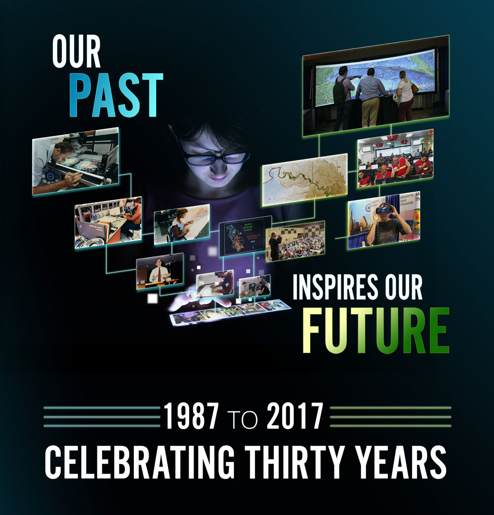
Special Presentation
History of GIS in Texas

View Photo Slideshow
12:00 - 1:15PM
Lunch & Exhibits

Lunch Sponsored by Merrick & Co logo

1:15 – 2:15PM

Platinum Sponsor Presentation
Esri Logo

2:15 - 2:30PM
Break & Exhibits
2:30 - 3:45PM

Guest Speaker
Todd Mostak, CEO of MapD

Head shot of Todd Mostak GPUs & Their Role in Geovisualization

As a research fellow at the Computer Science & Artificial Intelligence Lab at MIT, Todd recognized the possibilities behind the mechanics of Xbox and PlayStation to transform traditional data analytics platforms. Replacing his CPU for a GPU, Todd was one of the first innovators to discover the untapped potential of GPUs to analyze, visualize and explore data in ways never done before. Now? He is reducing query times from hours to milliseconds for companies like Verizon, Amazon, Simulmedia and npm, enabling them to spend significantly less time crunching data and more time analyzing it to make key business decisions.


Guest Speaker
Joanna Sanchez, Educational Policy Researcher at Howard University

Head shot of Joanna SanchezJoanna was born and raised in the Texas Rio Grande Valley, and earned her undergraduate degree in Geosciences from Trinity University. Joanna’s work with her non-profit, Odisea, and the Gates Millennium Scholarship Association and Hispanic Scholarship Fund (she is a recipient of both), inspired her to go back to school. In 2017, she earned her Ph.D. in the Department of Educational Leadership and Policy at UT-Austin where she conducted research projects incorporating the use of GIS and spatial analysis to explore research and policy questions. She gained policy experiences with Texas State Representative Mary González and as a policy fellow with the White House Initiative on Educational Excellence for Hispanics. She is currently a postdoctoral research associate in K-12 STEM Education at Howard University.

View Slides

3:45 - 4:00PM
Break & Exhibits
4:00 - 5:30PM

Guest Speaker
Sean Wohltman, Geospatial Scientist at Google

Head shot of Sean WohltmanSean is a Geospatial Scientist for Google’s Maps Customer Team. He has most recently been the technical lead for Google’s Enterprise Aerial Orthoimagery program and designed the workflows for provisioning and serving terabytes of imagery at scale on Google Cloud Platform. Since joining Google in 2008, he has worked to bring analytic capabilities to Google’s Geospatial platform and developed technologies to bring Google Earth and Maps to disconnected tactical and crisis-response environments. Prior to joining Google, Sean worked as a geospatial analyst in the Office of Counterterrorism and as a developer in the eGEOINT Management Office at NGA. He earned a bachelor's degree in geography from Virginia Tech in 2004, where he also earned his M.S. in geographic information science in 2005.
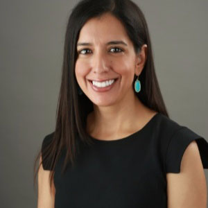

Guest Speaker
Kyle Walker, Urban Studies Director at Texas Christian University

Head shot of Kyle Walker

Kyle Walker is an associate professor of Geography and Director of the Center for Urban Studies at Texas Christian University. His research focuses on the demography of US cities and suburbs, internal migration trends in the United States, and tools for open data science. At TCU, Kyle teaches courses in urban studies, data analysis, and Geographic Information Systems. He holds a Ph.D. in Geography from the University of Minnesota.

Conference
Thursday, October 26

7:30 - 8:30AM
Registration & Breakfast
8:30 - 9:00AM
Welcome & Introductions
ALL DAY
9:00AM - 3:00PM

ESRI HOLL (FREE Hands-On Learning Labs)

Throughout the day on Thursday, ESRI will host self-guided courses in the Balcones Room covering ESRI software and key GIS techniques.

Stay tuned for course offerings.

9:00 - 10:30AM

Session A (Big Tex)
Data Availability & Management

9:00 – 9:30AM
Geodetically Accurate GIS with Real-Time Map Services Linking to Surveying and Engineering Design CAD Using ETL Tools

Stacey Lyle, TAMU | Jerry Jaynes

9:30– 10:00AM
Digging Deeper: Detailed GIS Data Management for NG9-1-1

David Peck, West

View Slides

10:00 – 10:30AM
Database to Dot Com: Using Query Layers and ArcGIS Online to Maintain Up-to-Date Data

John Phillips, TxDOT

View Slides

Session B (Li'l TEX)
Application Design

9:00 – 9:30AM
Leveraging Geospatial Technology to Increase Local Government Transparency for the Sidewalk Program Projects

Daniel Haverlah & Coleen Gentiles, City of Austin

View Slides

9:30 – 10:00AM
Exploring Demographic and Socioeconomic Indicators for Texas with an Online Dashboard Application

Jeffrey Jordan, IDSER; Saloni Rajput, TDC

10:00– 10:30AM
Simple Steps to Create User Friendly Mobile Web Map Applications

Stephanie Long, Austin Community College

View Slides

10:30 - 11:00AM
Break & Exhibits

Coffee break Sponsored by Fugro logo and link

11:00AM– 12:00PM

Platinum Sponsor Presentation
AppGeo Logo

12:00 - 1:30PM
Lunch & Exhibits

Lunch Sponsored by Merrick & Co logo

1:30 - 3:00PM

Session A (Big Tex)
Open Source GIS

1:30 – 2:00PM
Improving Business Agility with Geo-Enabled Business Processes, Microservices & Containerization

Jeremy Bixby, John Branigan, Boundless

View Slides

2:00 – 2:30PM
Web GIS on a Shoestring

Brent Porter, UT-CSR

2:30 – 3:00PM
Geospatial Analysis in the cloud with Carto Builder

Rod Erickson, CARTO

Session B (Li'l TEX)
Project Start to Finish

1:30 – 2:00PM
Developing Near-Real-Time Flood Impact Mapping in Texas

David Arctur & Harry Evans, UT-CRWSR | Michael Ouimet, Texas Division of Emergency Management | David Maidment, UT Austin

View Slides

2:00 – 2:30PM
Let’s Walk! Using GIS to Help Fort Worth’s Safe Route to Schools Program

Chris Akin, Dunaway Associates

2:30 – 3:00PM
UT Libraries: Enabling open access to cross-disciplinary research through spatial discovery

Jessica Trelogan, UT Libraries
3:00PM
Break - Board Buses for Keynote and Social Event at the Oasis
4:30 - 5:30PM

Special Keynote
Saroo Brierley

Head shot of Keynote Saroo BrierleyLost as a child, Saroo tracked down his hometown in India using Google Earth and his memories. His story inspired the Oscar-nominated film, Lion.

5:30PM

Forum Social at the Oasis

Oasis30 years of the Texas GIS Forum will be celebrated with a spectacular social event at the Oasis on Lake Travis, the Sunset Capital of Texas. Thanks to our Platinum Sponsors, we will celebrate this milestone occasion with an inspirational keynote speaker, amazing entertainment, scrumptious food and drink, and a knock-your-socks off view.

6:45PM
Sunset
7:30PM
Board buses to return to Commons Learning Center

Conference
Friday, October 27th

7:30 - 8:15AM
Registration & Breakfast
8:15 - 8:30AM
Welcome & Introductions
8:30 - 10:00AM

Town Hall: State of the State

GIO update presentation followed by an all-hands discussion on what's been done and where we are going?

10:00 - 10:15AM
Break
10:15 - 11:30AM

Education and Professional Development Panel

Needs and expectations in workforce relating to education and professional development.

11:30AM - 12:00PM

Introduction to the Texas Mentorship Program

12:00PM

Closing Remarks

Platinum Sponsors


appgeo logo and link to website Esri logo and link to website Esri logo and link to website Boundless logo and link

Gold Sponsors

Aecom geospatial logo and link Lenovo geospatial logo and link Near map logo and link Plotter Pro Logo and link to website Surdex geospatial logo and link

Silver Sponsors

Carto logo and link Fugro logo and link GeoComm logo and link Hexagon logo and link Infogroup logo and link HP geospatial logo and link Sanborn logo and link to website SCAUG logo and link West Safety Services logo and link Geocortex logo and link

Exhibitors

  • Blue Marble Geographics
  • RazorTek
  • TeachMeGIS
  • Tessellations Incorporated
  • Western Data Systems